FAMINES IN THE INDIAN SUBCONTINENT, 1500 to 1767![]()
The government treatise "Arthashastra" from the 4th century BCE described a rain-gauge, but no records of measurements survive. Although some Europeans kept sporadic weather records at their Indian homes in the late 18th century CE, it has only been possible to compile a continuous record of rainfall in India from 1813 onward.
N.A. Sontakke et al. "Instrumental period rainfall series of the Indian region (1813-2005): revised reconstruction, update and analysis" (in "The Holocene" vol. 18, no. 7, 2008) [tables online at http://www.tropmet.res.in/static_page.php?page_id=52 ] Annual Indian rainfall averages over 45 year periods: 1813-1857, 1116.4mm; 1858-1902, 1149.2mm; 1903-1947, 1162.6mm; 1948-1992, 1166.5mm; [1993-2006, 1174.1mm] Whole India, twenty lowest and five highest rain years 1813-2006 (order L-H):
L: 1838 (868.8mm), 1899 (891.1mm), 1918 (895.9mm),1848 (926.6mm), 1860 (927.9mm), 1965 (931.5mm), 1972 (932.7mm), 1855 (935.7mm), 1832 (948.0mm), 1864 (949.9mm), 1868 (955.4mm), 2002 (968.9mm), 1840 (972.2mm), 1905 (973.5mm), 1823 (976.9mm), 1876 (979mm), 1877 (985.8mm) [i.e. 1876-1877 is the only consecutive pair of sub-1000mm years on record], 1979 (1001.7mm), 1951 (1001.9mm)
H: 1893 (1385.2mm), 1956 (1387.9mm), 1961 (1409.7mm), 1827 (1410.9mm), 1917 (1435.2mm).Four lowest and two highest rainfall years (order L-H) per region [starting 1848, as regional coverage is patchy before then]:
North Mountainous India, L: 1848, 1860, 1902, 1991; H: 1917, 1894.
North West India, L: 1918, 1899, 1848, 1868; H: 1961, 1917.
North Central India, L: 1864, 1979, 1966, 1965; H: 1894, 1971.
North East India, L: 1873, 1896, 1982, 1972; H: 1988, 1861.
West Peninsular India, L: 1899, 1920, 1918, 1972; H: 1892, 1878.
East Peninsular India, L: 2002, 1899, 1876, 1920; H: 1936, 1893.
South Peninsular India, L: 1876, 1860, 1855, 1881; H: 1852, 1961.
However, it is possible to obtain "proxy" data from objects which develop over multiple centuries in ways related to weather, such as teak trees, and Himalayan glaciers. Even tiny air bubbles trapped within glacial ice have some remarkable stories to tell, via measurements such as the concentration of the isotope Oxygen-18 (usually denoted 18O). Tree-ring measurements are being utilised to create a project called MADA (Monsoon Asia Drought Atlas), which is available online, for example at
https://iridl.ldeo.columbia.edu/SOURCES/.LDEO/.TRL/.MADA/index.html?Set-Language=en
At the time of writing (late 2017), I feel MADA does not yet have enough pre-1800 data from India to be reliable for the period and regions I am studying, but do check it out; using its system takes a bit of practice, but the results are fascinating. Here, for comparison, in a slightly frivolous spirit of scientific enquiry, is a compilation of proxy measurement graphs used to illustrate various relevant articles in scientific journals, re-sized and lined up so that their chronologies match (click on the image to enlarge) [NB: The less jagged lines in bright colours on these graphs are averages of a decade or more, which are not so relevant when studying short-term phenomena such as droughts]. The sources for the graphs are listed below the image.
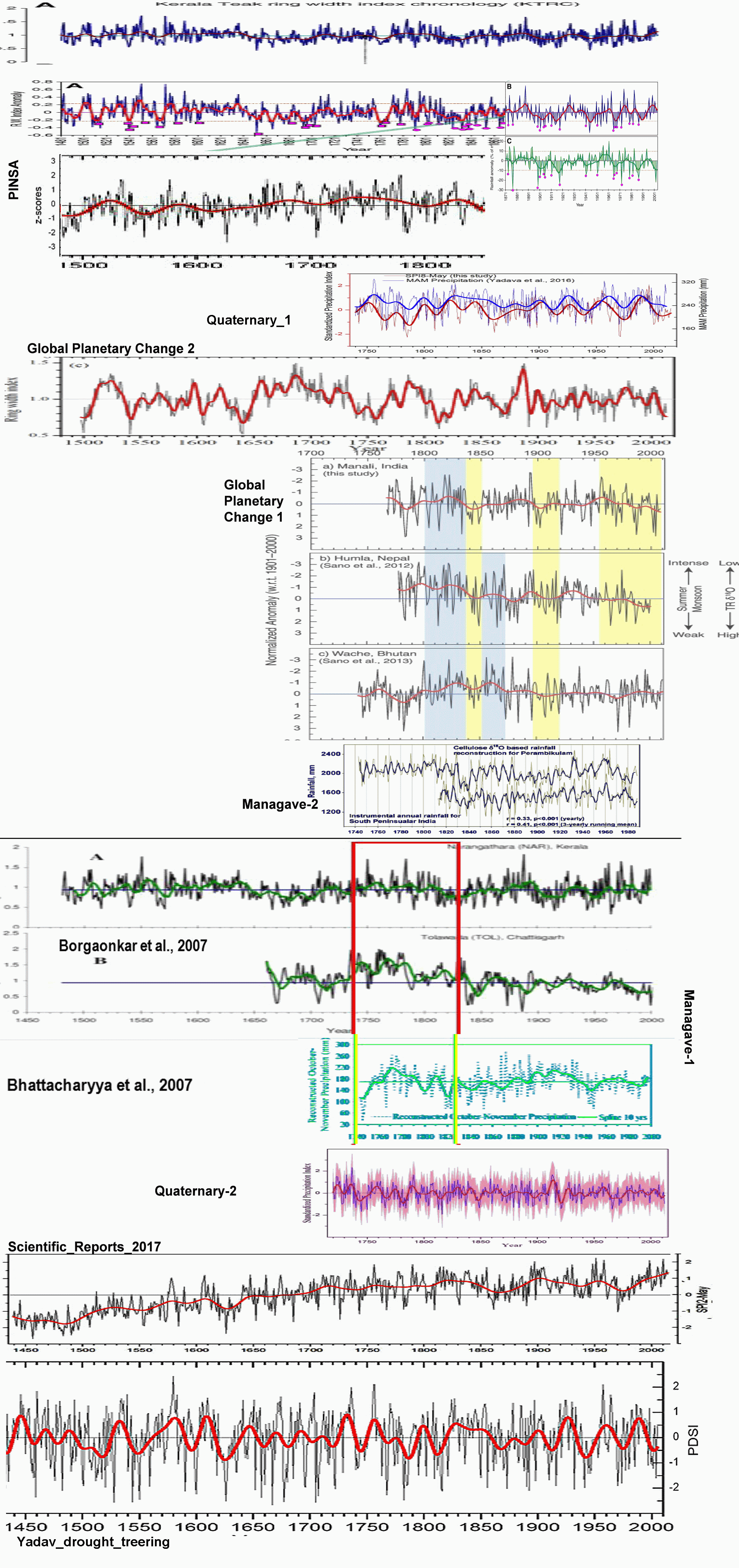
| Kerala teak ring width [top two graphs inc. B & C] |
| H.P.Borgaonkar et al. "El Nińo and related monsoon drought signals in 523-year-long ring width records of teak (Tectona grandis L.F.) trees from south India" (in "Palaeogeography, Palaeoclimatology, Palaeoecology" vol. 285, Jan 2010; pp 74-84) From the abstract: "a 523-year (A.D. 1481–2003) tree-ring width index chronology of Teak (Tectona grandis L.F.) from Kerala, Southern India, prepared from three forest sites. Dendroclimatological investigations indicate a significant positive relationship between the tree-ring index series and Indian summer monsoon rainfall (ISMR) and related global parameters like the Southern Oscillation Index (SOI). ... many low tree growth years are detected during known El Nińo events, probably related to deficient Indian monsoon rainfall. The general relationship between ISMR and El Nińo is known to be negative and the spatial correlations between our Kerala tree-ring chronology and sea surface temperatures (SSTs) over the Nińo regions follow similar patterns as those for ISMR." |
| PINSA |
| Rajeev Patnaiki et al., "
Indian Monsoon Variability at Different Time Scales: Marine and Terrestrial Proxy Records" (in "Proceedings of the Indian National Science Academy" vol. 78 no. 3, Sep 2012; pp 535-547) Cropped version of Figure 8: "August-July precipitation reconstruction (AD 1330-2008) for Lahaul-Spiti region, Himachal Pradesh using tree-ring data network of Himalayan cedar. The thick line represents the 50-year low pass filter (Yadav, 2011a )" From the abstract: "... a review of the work done in India during 2007-2011 on various proxy records of monsoon variability preserved in the marine (Central Indian Basin, western, northern and eastern Arabian Sea and the Bay of Bengal) and terrestrial (Northeast, Gujarat, Himalayan Lakes, Siwaliks, Thar Desert, Ganga Valley, etc.) realms ..." |
| Quaternary 1 |
| Vikram Singh et al. "Tree ring drought records from Kishtwar, Jammu and Kashmir, northwest Himalaya, India" (in "Quaternary International" vol. 444, 15 Jul 2017; pp53-64) From the abstract: "... a 275-years (A.D. 1740–2014) long Standardized Precipitation Index (eight months SPI of May, SPI8-May) reconstruction using ring-width chronology of Himalayan cedar (Cedrus deodara (Roxb.) G. Don) from Kishtwar, Jammu and Kashmir ... The reconstructed SPI8-May series showed very good consistency with tree–ring-based upper Indus basin discharge and gridded summer (June–July–August) PDSI data of the northwest Himalaya–Karakoram region." |
| Global Planetary Change 2 |
| Shankar Panthi et al. "Tree rings reveal recent intensified spring drought in the central Himalaya, Nepal" (in "Global and Planetary Change" vol. 157, Oct 2017; pp 26-34) From the abstract: "we developed new tree-ring width chronologies of Himalayan spruce (Picea smithiana (Wall.) Boiss.) from three sites in the north-western Nepal. The local site chronologies showed high cross correlations and similar growth-climate responses to regional spring drought variability. ... Spectral peaks and spatial correlation analysis indicate that spring drought variability in the central Himalaya may be linked to large scale climatic drivers, mainly Atlantic Multidecadal Oscillation activities due to sea surface temperatures variation in the Atlantic Ocean. ..." |
| Global Planetary Change 1 [graphs a to c] |
| Masaki Sano et al. "Moisture source signals preserved in a 242-year tree-ring δ18O chronology in the western Himalaya" (in "Global and Planetary Change" vol. 157, Oct 2017; pp 73-82) From the abstract: "a 242-year δ18O chronology calculated from five silver fir trees collected in the western (Indian) Himalaya, a region located on the northwestern periphery of the summer monsoon incursions. ... Our chronology showed significant correlations with other tree-ring δ18O data from Nepal and Bhutan, indicating that common signals related to the moisture supply from the Bay of Bengal are also recorded in the present reconstruction. However, the tree-ring record from India often showed weak correlations with that from Bhutan, especially when the summer monsoon was relatively weak. This result, together with the fact that the water vapor at the tree site was also derived from the Arabian Sea, implies that a weaker monsoon circulation enhances the flux of Arabian Sea moisture and reduces the flux of Bay of Bengal moisture to the study region." |
| Managave-2, and Managave-1 (graphs from two 2007 papers) |
| Shreyas R. Managave et al. "What can be learnt from oxygen isotopes composition of teak tree rings from India? Rainfall reconstruction up to AD 1743" [ http://slideplayer.com/slide/4183548/ ] based on: Shreyas R. Managave et al. "Response of cellulose oxygen isotope values of teak trees in differing monsoon environments to monsoon rainfall" (in "Dendrochronologia" vol. 29, no. 2, 2011; pp 89-97) Managave-2 slide caption: "Comparison with regional rainfall record. Higher rainfall during the later part of the Little Ice Age ..." Managave-1 slide caption: "Other evidences of higher rainfall. Borgaonkar et al., 2007. Bhattacharyya et al., 2007" [NB: I have colour-shifted some of the Managave graphs to increase legibility] |
| Quaternary-2 |
| Ram R.Yadav et al. "Tree-ring footprints of drought variability in last ˜300 years over Kumaun Himalaya, India and its relationship with crop productivity" (in "Quaternary Science Reviews" v117, 1 Jun 2015, pp113-123) From the abstract: "... reconstructed Standardized Precipitation Index (SPI), a metric of drought, using tree-ring width chronologies of Himalayan cedar (Cedrus deodara (Roxb.) G. Don) prepared from two ecologically homogeneous settings in the Kumaun Himalaya, India. ... The SPI reconstruction revealed high year-to-year variability with 1816 (SPI -1.92) and 1737 (SPI +2.33) the driest and the wettest years respectively. The five year mean of reconstructed SPI revealed multiyear droughts in 1920–1924, 1782–1786, 1812–1816, 1744–1748, 1964–1968 and pluvial phases in 1911–1915, 1723–1727, 1788–1792, 1758–1762 and 1733–1737. The SPI7-May was found to be significantly correlated with wheat-barley productivity data of Almora in Kumaun, close to our tree ring sites (r = 0.60, two-tailed p < 0.0001). However, we observed that the wheat-barley productivity data, to some extent, were better correlated with 7-month SPI of April (SPI7-April) (r = 0.69, two-tailed p < 0.0001). The difference in relationship of wheat-barley productivity and SPI of above two periods is largely due to the prevailing crop phenology in the region. The wheat and barley crops sown in October–November are usually harvested in May when the Himalayan cedar trees are in active vegetation phase of seasonal growth in Almora region." |
| Scientific Reports 2017 |
| Ram R. Yadav et al. "Recent Wetting and Glacier Expansion in the Northwest Himalaya and Karakoram" (in "Nature: Scientific Reports 7" article number 6139, 21 Jul 2017) Figure 3: "SPI2-May reconstructed series (A.D. 1439–2014). The thick line superimposed on the reconstruction is 40-year low pass filter." From the abstract: "... Applying a network of annually resolved tree-ring-width chronologies from semi-arid region of Kishtwar, Jammu and Kashmir, India, we reconstructed April-May standardized precipitation index extending back to A.D. 1439 (576 years). The reconstructed series is featured by the most conspicuous long-term droughts during the 15th to early 17th centuries followed by a general wetting, with 1984–2014 being the wettest interval in the past 576 years. ..." |
| Yadav drought treering |
| Ram R. Yadav "Tree ring–based seven-century drought records for the Western Himalaya, India" (in "Journal of Geophysical Research: Atmospheres" vol. 118, 27 May 2013, pp4318-4325) Cropped version of Figure 4: "OM PDSI reconstruction (1310–2005 A.D.) for the western Himalaya overlaid with 20 year low-pass filtered version (thick line)." From the abstract: "... The reconstructed OM PDSI series showed a negative relationship with mean summer temperature (May–August) [Yadav et al., 2011] developed for the western Himalayan region (r?=?-0.17, p?<?0.0007; 1310–2005), endorsing that wet (dry) winters are associated with cool (warm) ensuing summers. ... It should be noted here that the present OM PDSI reconstruction is completely independent of MADA [Cook et al., 2010] as they do not share any common tree ring data." |